
Annonsørinnhold fra PSS-GEO
“The Elephant!”
In just a few days, the LinkedIn post got more than 10 000 views and 100 likes attracting the attention of the G&G people over the world to the North Sea 3D cube that was computed using AI technology. A massive volume of data was quickly converted to the lithological cubes, which was met with both skepticism and enthusiasm among the experts. The skepticism: even when using modern techniques, it is technically impossible to predict what was predicted in this 3D cube using post-stack seismic data. Or isn’t it? The enthusiasm: the post states that only 72 hours were used to compute on the PSS-Geo cluster. Can we skip months of exploration work and jump to analyzing after only a few hours of machine computation?
– “Not really but nearly”, commented Barbara Eva Klein from Pre Stack Solutions-Geo (PSS-GEO).
«This technology was first tested in PSS-GEO in 2019. At that time, it had already been a couple of years since the AI boom in the industry and the starting of the oil and gas crisis. We saw a need for change in exploration – propose an affordable solution without compromising on the quality. In our estimation, the developed AI technology would reduce the cost of exploration from 10-12,000 USD per sq. km to 2,5-5 USD per sq. km. So, yes, it will not be popular amount those who try to sell as “expensive as possible, and as “complicated as possible”. Of course, any technological development comes with a cost and involvement of many people. Our solution is simple and elegant. It took us just a year and four months to be granted the patent and was approved at once by WIPO. This does not happen often.
Think about it: How many AI solutions have been developed in recent years? Plenty! Are they all useful? Hardly. Any breakthrough in geophysics? Not really. However, we feel that our AI solution brings radical changes and deserves attention».
The trick
What’s new? Predicting the independent Velocity and Density of the rocks is impossible in conventional geophysics. They are linked, making all inversion results doubtable, and therefore not much used amount the very senior explorationists.
Here arrived AI solutions to overcome this problem, which is radically new in geophysics. Those two key parameters (independent P-wave and Density) let PSS-Geo predict its «Elephant.» PSS-Geo found a good optimization solution to a global optimization problem. To put it simply, let us assume that we have a true solution. We now search all possible solutions varying from minimum to maximum (the closest one to the truth and the one furthest). When we find the closest solution we save it as the right one. In mathematics, a global optimization algorithm allows us to jump to the global minimum (the most accurate solution), skipping local minimums, which are often cases in stochastic approaches.
Now, how is this global optimization algorithm implemented here? We have a seismic gather. It can be formed by combining P-wave, S-wave, and Density. Let’s search for these tree parameters independently from random samples and create the synthetic gather. When this synthetic gather starts to look like the real one (the true solutions – the global minimum), we output P-wave, S-wave, and Density as the true ones. It is not an easy search. It can reach up to 2,000,000 iterations per gather. In comparison, the conventional seismic inversion algorithm reaches an average of 30-50 iterations. You will need machines to manage so many iterations.
How can we possibly implement this on just one trace (post-stack)? Conventionally post-stack seismic can be converted to P-impedance that is equal P-wave*Density. Let us say P-impedance is 2500 m/s*(g/cc). P-wave and Density can mathematically be any number. But we are in the field of geophysics and that means we have limitations. There is a strict rule on how reflected seismic signal forms. That brings the limitations on the Density and P-wave ranges. This rule defines the artificial constraints that are further used in true solutions search as criteria for a global optimization algorithm. This task is easier for the machines and reaches a maximum of 500,000 iterations per trace.
Most importantly, the accuracy in this approach will be higher than in the conventional inversion processes. Accurate and, most importantly, independent P-wave and Density have not yet been calculated in the conventional approaches.
Data preparation is important
– No matter what algorithm you have for inversion, data preparation is key, said Barbara. – To build the merge and invert it, we had a team of eight people. For the inversion, it is important to use only true amplitudes data. Public data with the true amplitude is not available everywhere in the North Sea area of NCS. So, we went through all data and carefully selected the surveys without AGC, other possible scaling or spectral shaping.
The next step is phase control. Old surveys often had a minimum phase (90°). We also found many surveys with a phase of 55°. We used wells to control the phase and bring every survey to 0-phase. 3 to 10 wells were checked per survey to find the correct phase. To match the surveys and QC their phases, we used a cross-correlation process between the different datasets.
In addition, we applied post-stack processing to all surveys, trying to make the vintage public data look like the modern data. We performed de-ghosting and de-noise processes. This seismic processing step was done easily thanks our PSS-Geo duo: Rune Øverås and Marcin Kaluza. Rune is the brain behind most of our algorithms, developing true operator-based de-ghosting in all possible domains back in 2013. He is also the author of our AI inversion. As for Marcin, he has worked as lead geophysicist in numerous projects in the Barents Sea for MCG, Spectrum and others. As a team, we reprocessed data and did pick shallow velocity better than FWI, – says Barbara smiling. Our 2017 Barents Sea’s imaging is still very competitive.
So, what I want to say is that it was not difficult to uplift the quality. Ask AkerBP or Lime Petroleum. They showed us pictures comparing our “Elephant” merge with modern data, where our «Elephant» gave a better image. Of course, modern data can have longer cables and a broader band with better imaging in the very dip part compared to the vintage one. In some areas of the merge, the old data is of very good quality even by modern standards. I remember we got a question from a client if we could uplift their data to the same look. – Barbara smiling again.
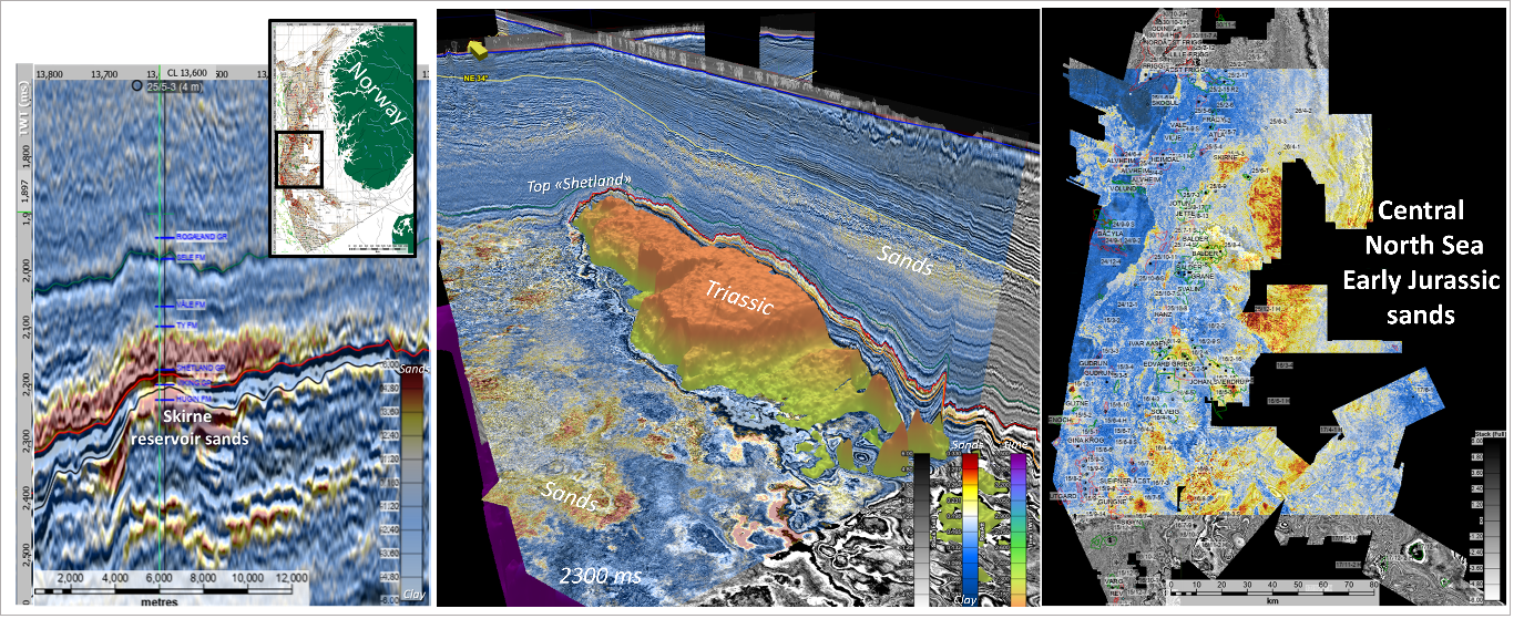
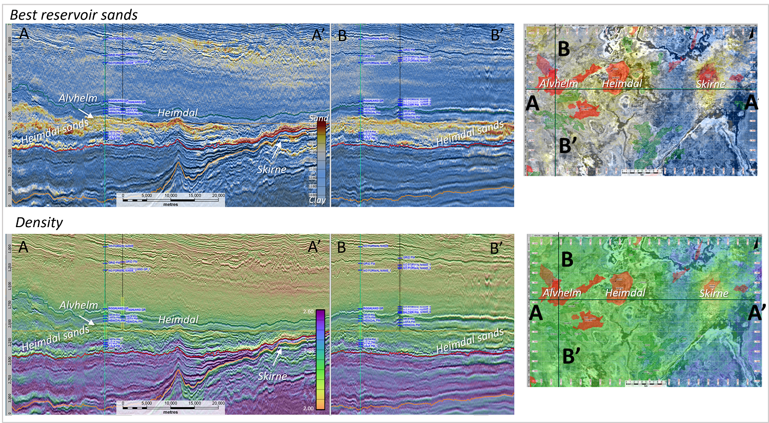
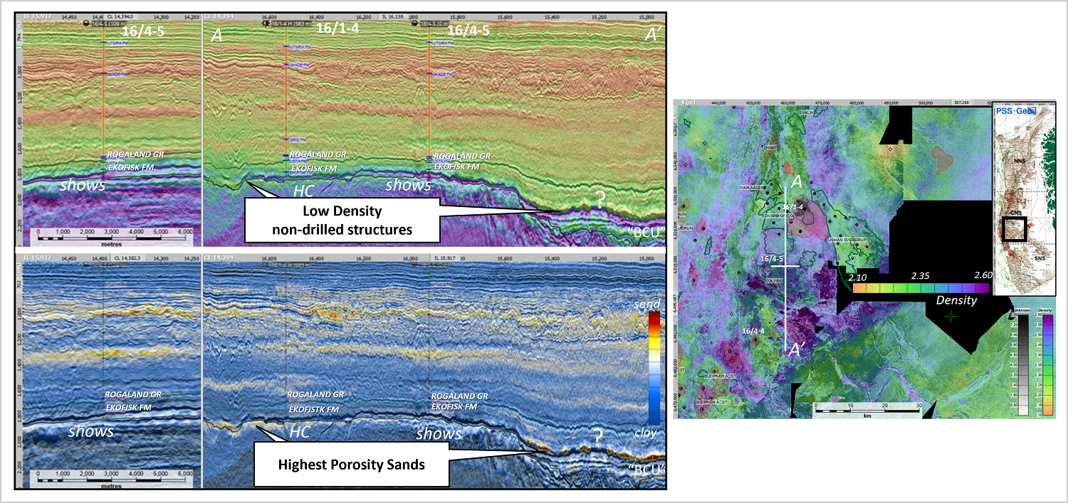
Another important and tricky moment in the merging process is the use of a scaling function to match amplitudes with emphasis on preserving rock contrast for the inversion. For the inversion process, we used horizons mainly provided by Lime Petroleum. It was important to have them accurate, not regionally picked and interpolated, in order to build initial models. We tied 722 wells – the check shots were correct in it and we built low-frequency models of P-wave and Density using those horizons. 72 hours of computing later, we had P-wave and Density cubes.
Vclay and Porosity from post stack.
We compute Vsand using the Gyllenhammar formula, adjusting clay points for different formations. If you are interested in reading more about this, you can have a look at the article “Calculating a synthetic density curve using a volume of clay and velocity” from the First Break magazine (June 2020). It is impossible to predict Vclay and Vsand precisely using this approach. We can though indicate with good confidence where the “clean” sands and where the “clean” clay are. Right now, we do not have a carbonate scheme and it is not predicted in our cubes. But this is, I believe, just a matter of time in the near future. We compute porosity from the density and Volume of clay. Here there can be different conventional schemes. And that’s it! Our Elephant is ready!
I want to add that it is really fascinating to surf through this unique cube, observing the sands and density drops in it, this being the first indication of possible reservoir.
We are happy to share a couple of examples with the Geo365 readers.
And the next step for us will be an application of our ML algorithms to indicate HC in this cube. We presented that technique at DIGEX this year.
Note: Pre Stack Solution-Geo is an independent geophysical company with the main office in Oslo, Norway, that has been providing geophysical services to many oil&gas companies since 2000 and contributing to the technologies development. Many useful solutions and great geophysicists came from the PSS-Geo, working today in different energy companies.
2 kommentarer
Brilliant results, guys!!! Amazing productivity and results performance!! Keep going, present us HC indication ML algorithm soon!!
Sections quality looks fantastic. If it works as described, it is really a breakthrough. Looking forward to see application of ML for HC indication.