Close Menu
    Facebook LinkedIn
    Geo365
    Facebook LinkedIn
    BESTILL Login ABONNÉR PÅ NYHETSBREV
    • Hjem
    • Anlegg og infrastruktur
    • Aktuelt
    • Bergindustri
    • Dyphavsmineraler
    • Miljø
    • Olje og gass
    • Geofunn
    • Download Media Guide
    Geo365
    You are at:Home » Newly discovered ridges point to greater resource potential
    Dyphavsmineraler

    Newly discovered ridges point to greater resource potential

    Three cruises in 2024 have given us better data coverage on the Mohn’s Ridge and the Greenland Sea. The results indicate a greater potential for sulfide deposits, as well as prospective areas for manganese crusts.
    By Ronny Setsåfebruar 20, 2025
    Del denne artikkelen Facebook Twitter LinkedIn Email

    Bathymetric map of the central part of the Greenland Sea and parts of the Mohn’s Ridge. The newly discovered east-west trending magmatic ridges (horizontal lines) may prove important in understanding where sulfide deposits occur. Illustration: Brekke et al., 2025 (conference abstract)

    Facebook Twitter LinkedIn Email

    Although the long-awaited licensing round for seabed minerals in Norway was paused late last year, data acquisition by the Norwegian Offshore Directorate (NOD) and the universities in Tromsø and Bergen carries on with full strength.

    We are pleased to announce that Harald Brekke, Senior Geologist at NOD, will present fresh cruise data and new insights from parts of the Norwegian Exclusive Economic Zone opened for mineral activities at the Deep Sea Minerals 2025 conference in Bergen in April.

    The 2024 cruises focused on the western flank of the Mohn’s Ridge and the Norwegian parts of the Greenland Sea. While legacy datasets provide a general understanding of the deep ocean floor’s depths, large seamounts, and the outline of the axial valley of the spreading ridge, they offer limited essential details. Additionally, the sediment successions and their regional distribution remain poorly understood.

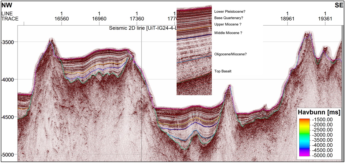
    In short, the cruise participants have acquired multibeam echosounder data, used a remotely operated vehicle (ROV) to investigate geological landscape evolution, map crust formations, and study biology and habitats in geologically significant areas. Furthermore, the third cruise gathered 2D seismic data from the Lofoten Basin in the east to the outer limits of the continental shelf in the west.

    Favorable for mineral deposits

    The findings confirmed that the seafloor spreading along the Mohn’s Ridge has occurred in two main phases. Of particular interest is the discovery of east-west trending magmatic ridges, as shown in the map above.

    These long-lived ridges (10 – 20 Ma) indicate stable magma sources. These may be viewed as favorable for hydrothermal activity and thus for the formation of seafloor massive sulfide deposits.

    Consequently, these ridges are promising targets for exploration companies. The researchers also note that some known sulfide deposits are located where the magma ridges intersect the current axial valley, including Gnitahei, Fåvne, Deep Insight, and Grøntua.

    Identifying barren surfaces

    The newly acquired seismic data is useful for improved understanding of the sedimentation processes and geological evolution. From a resource perspective, they may aid companies in locating barren basement surfaces that may host manganese crust deposits.

    Crusts are only formed in areas without the presence of sediments, which would normally be on seamount surfaces with slopes of at least 20 °.

    In conclusion, the NOD, UiT and UiB cruise results contribute to a better understanding of the geological processes shaping the seafloor within the opening area and help identify areas of interest for mineral exploration.

    Brekke’s talk will also include plans for upcoming cruises in 2025.

    Deep Sea Minerals 2025 will take place in Bergen from 1-3 April. The program and registration page can be found on the conference website.

    Seismic line with preliminary interpretation, showing correlations between sedimentary sections in basement lows and onlap sequences suggesting minor tectonic compression. The line is from a location north of the Mohn’s Ridge (see red line in the map above). Illustration: Brekke et al., 2025 (conference abstract)

    Related Posts

    Industrieventyret som glapp

    desember 18, 2025

    Kritiserer havbunnsmineral-stopp

    desember 17, 2025

    Første kobber fra det norske dyphavet

    desember 17, 2025
    Add A Comment

    Comments are closed.

    NYHETSBREV
    Abonner på vårt nyhetsbrev
    geo365.no: ledende leverandør av nyheter og kunnskap som vedrører geofaget og geofaglige problemstillinger relatert til norsk samfunnsliv og næringsliv.
    KONFERANSER

    Formidlingspris til Jan Mangerud 
    Dec 22, 2025

    Formidlingspris til Jan Mangerud 

    Michelsen lukker øynene for det som ikke passer
    Dec 22, 2025

    Michelsen lukker øynene for det som ikke passer

    Første kobber fra det norske dyphavet
    Dec 22, 2025

    Første kobber fra det norske dyphavet

    Kommer: GEO 2026 og Geokalenderen 
    Dec 22, 2025

    Kommer: GEO 2026 og Geokalenderen 

    Toktet i mål
    Dec 17, 2025

    Toktet i mål

    Where the earth yawns
    Dec 23, 2025

    Where the earth yawns

    When your oil reservoir turns out to be a lithium deposit
    Dec 22, 2025

    When your oil reservoir turns out to be a lithium deposit

    Subsurface noise, Issue 5, 2025
    Dec 19, 2025

    Subsurface noise, Issue 5, 2025

    Quantifying the hydrogen-generation potential of iron-bearing rocks
    Dec 18, 2025

    Quantifying the hydrogen-generation potential of iron-bearing rocks

    Mitigation, precaution, and exclusion zones: Aligning science with policy
    Dec 17, 2025

    Mitigation, precaution, and exclusion zones: Aligning science with policy

    OLJEPRIS
    BCOUSD quotes by TradingView
    GULLPRIS
    GOLD quotes by TradingView
    KOBBERPRIS
    Track all markets on TradingView
    GeoPublishing AS

    GeoPublishing AS
    Trollkleiva 23
    N-1389 Heggedal

    Publisher & General Manager

    Ingvild Ryggen Carstens
    ingvild@geopublishing.no
    cell: +47 974 69 090

    Editor in Chief

    Ronny Setså
    ronny@geopublishing.no
    +47 901 08 659

    Media Guide

    Download Media Guide

    ABONNEMENT
    NYHETSBREV
    Abonner på vårt nyhetsbrev
    © 2025 GeoPublishing AS - All rights reserved.

    Type above and press Enter to search. Press Esc to cancel.